97
Views & Citations10
Likes & Shares
Table 2 lists the noteworthy earthquakes that occurred in India in the recent past and were observed and studied by the organizations listed in Table 1.
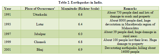
It is ironical to note that technically speaking, all the five earthquakes listed in Table 2 above fall in the category of "Moderate" having magnitudes between 5 and 6.9 on the Richter Scale. Yet, these were devastating enough due to other aggravating factors such as terrain, soil type, time of occurrence, weak infrastructure and vulnerability of the affected people (Bolt, 1988). We shall present detailed case studies of the two more devastating earthquakes Latur & Bhuj each of which resulted in thousands of deaths. But before that, short descriptions of the other three earthquakes (Uttarkashi, Jabalpur & Chamoli) may be given.
Uttarkashi earthquake
Garhwal Himalayas are well-known for earthquakes of damaging magnitude. According to the seismic hazard map of the country, this region falls under zone IV and V, which are severe most hazard zones (Dowrick, 2003). The region has faced earthquakes of magnitude 6.0 Or more at an average interval of 8 to 9 years. An earthquake of magnitude 6.6 rocked the Garhwal region in the night hours (02.53 h.) of October 20, 1991. The epicenter of this earthquake was near the Uttarkashi town. Widespread damage was reported in the hilly area in the wake of this earthquake. There was a death toll of about 750 with 5000 injured and widespread damage in the districts of Uttarkashi, Tehri and Chamoli. About one lakh houses were damaged-20 percent of them totally. Immediate rescue and relief works were hampered due to severe damage to roads and bridges. The services of Army and Para-military forces were pressed into service to manage the situation. Helicopters were used to reach far-off places. The Government of Uttar Pradesh aided the affected community in cash and kind. Volunteers from NCC and NSS and many NGOs did exemplary relief work Reconstruction projects were funded through HUDCO and IAY.
Jabalpur earthquake
As per the seismic hazard map of India, Jabalpur and surrounding areas fall under the seismic zone Ill, A magnitude 6.0 earthquake rocked the state of Madhya Pradesh on May 22, 1997 at4:20 AM. in the early morning. The epicenter of the earthquake was located near Jabalpur city. About 40 people lost their lives. One of the important reasons for less number of human casualties was the peak summer season, when most of the people were sleeping outdoors or were already awake in the early morning. This earthquake, destroyed 15000 houses and partially damaged about 3.00 lakh dwelling units. As most of the houses were "Kutcha" or semi Kutcha construction with terracotta-tiled roofs, the damaged houses did not kill many persons.
The Government of Madhya Pradesh along with NGOs assisted the affected community by providing medical help, temporary shelters, food / food items, utensils and clothes etc. In addition, the Government provided financial assistance to the affected community to carry out necessary repair and restoration works.
Chamoli earthquake
An earthquake of magnitude 6.8 struck the Garhwal Himalayas on March 30, 1999 at 12:55 AM. i.e. at midnight. Incidentally, this was about 8 years after the Uttarkashi earthquake. The epicenter of this earthquake was near the town of Chamoli. About 100 people lost their lives. Almost 5 lakh people were affected in the Districts of Chamoli, Rudra Prayag and Pauri Garhwal. Very severe damage was reported from the town of Chamoli and surrounding areas. The services of Army and Para-Military Forces were utilized very effectively for search and rescue operations; for clearing the roads, which were blocked due to landslides and damaged bridges and in relief works.
EARTHQUAKE CASE STUDIES
Latur Earthquake, 1993
An earthquake of magnitude 6.4 on Richter Scale) struck the State of Maharashtra on September 30,1993 in the early morning at 0 3.54 hours. The epicenter of the earthquake was near village Killari in Latur district. The focal depth of the earthquake was about 15.00km below the surface of the earth. The earthquake was felt over long distances in the adjoining states of Andhra Pradesh and Karnataka also.
Seismic History of the Region
The region had a seismic history although geologically it was located in a stable continental region (SCR). Village Killari, which was the epicenter of the 1993 earthquake, had earlier also experienced tremors in 1962, 1967 and in 1983. In 1992, enhanced seismic activity was observed when 125 shocks took place between August and October, including one earthquake of magnitude 4.5 on October 18, 1992. Damage to houses took place even due to this earthquake shock of "slight" category. This was because most of the construction was done using locally available stones with only mud plaster to hold them.
Damage due to the Latur Earthquake of 1993
Heavy damages were reported from a localized area of 20 x 20 km around the epicenter. This earthquake is famous for huge devastation of stone houses in the rural areas.52, villages in the districts of Latur and Osmanabad were razed to the ground. In all about 29000 houses were destroyed, while another 170,000 houses received damages in varying proportions. Due to collapse of stone houses about 8000 people lost their lives and 16000 were. injured. Infrastructural damages were also very severe especially in the two worst affected districts of Latur and Osmanabad. School buildings were the worst affected and so were also the buildings of government departments and gram panchayats. Total infrastructural damage was estimated to be of the order of Rs. 22 crores at least.
Rescue and Relief
Response to the post-earthquake management was spontaneous and tremendous. Government of Maharashtra officials including the Chief Minister rushed to the affected area for making on· the spot assessment and to share the grief of, the community. To facilitate the smooth functioning and to avoid distraction of the administrative machinery, the Chief Minister camped in the nearby district. Assistance of Armed Forces was sought in search and rescue operations and to clear the debris. The Armed Forces also helped the civil administration in restoration of emergency services like communication, electricity and transportation systems. Gathering of very large number of sightseers hampered the relief and rescue operations. Death of a large number of people in villages created problems in disposal of dead bodies. Wood was not adequately available in the initial stages. The salvaged wood from the damaged houses was used for cremation of dead bodies. Mass cremations were carried out in open spaces, which created difficult condition for the grief-stricken people in the affected areas.
People in the affected villages were not left even with roofs on their heads. Arrangements for temporary shelters were made in the vicinity of the destroyed villages. Similarly, arrangements for adequate supply of food, and potable water, were made. Army personnel helped the civil authorities in the emergency phase in an effective manner.
The Army succeeded in rescuing about 9000 people from the debris. In this situation, along with the treatment of injured, medical teams were deputed to take up the preventive measures against the spread of disease and epidemics. Provisions were made for temporary relief shelters, which were made up of Gil. (Galvanized Iron) sheeted roofs over bamboo or wooden frames. These shelters were provided to 30,000 (approx) families in Latur and Osmanabad, which were the worst affected.
The response of voluntary groups which came after the earthquake was indeed overwhelming. The immediate response groups mainly comprised local religious bodies and charitable trusts. They responded immediately by undertaking mass feeding programmes and free distribution of essential items such as clothes, utensils and other necessities. Prominent among such organizations were Akhil Maharashtra Jain Singh, Gurudwara Mandal, Seva Bhavi Sanstha and Gurudwara Siddha Peeth. Besides such groups, a number of local and international NGOs sent medical teams and supplies to the site.
Another category of organizations that played a vital role were those involved in developmental activities in different pans of the country. These organizations came forward to help the Government in long-term rehabilitation and reconstruction programmes, the organizations comprised religious and charitable agencies who in turn were provided with financial, infrastructure and research support by a number of private corporate houses, public sector organizations, and research and development agencies.
Rehabilitation of Affected Areas
The Maharashtra Reconstruction project was one of the most comprehensive mitigation projects ever taken up in the country. This earthquake is famous for the efforts of the Government of Maharashtra to rehabilitate the earthquake-affected area on a very large scale. The affected area was spread over 13 districts having more than 2 lakh houses with various levels of damage. After careful evaluation, the Government of Maharashtra rehabilitated 52 villages on new sites. More than 27000 houses were constructed in these villages in three different categories. The houses were allotted to the villagers based on the economic background of the households. The contribution from non-governmental organizations and the private sector was significant in this rehabilitation programme. Newly built villages have all the necessary functional facilities. The houses constructed adhered to the seismic building code requirements. A large number of houses were rebuilt on the old sites as well. Similarly, a very large number of houses were retrofitted and repaired for providing adequate and necessary seismic strength. In all about houses in 2400 villages were rebuilt, repaired or retrofitted.
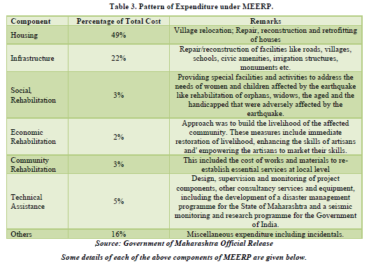
The Government of Maharashtra launched the Maharashtra Emergency Earthquake Rehabilitation Project (MEERP) with the financial assistance from the World Bank, the Central Government and other donor and bilateral agencies. The MEERP had the following major components: housing, infrastructure, community rehabilitation, economic rehabilitation, social rehabilitation, technical assistance (training and equipment etc.), and miscellaneous/other items. The expenditure pattern on these components was as listed in Table 3.
HOUSING CONSTRUCTION AND REPAIR
Under the rehabilitation programme, 49 villages were rehabilitated on new sites with 23000 houses and all necessary infrastructure and amenities. 29,600 houses were reconstructed while 1,80,000 houses were retrofitted, for better earthquake resistance.
Infrastructure
This comprised repair, reconstruction and strengthening of public buildings and other infrastructure including schools, health centers, social service facilities, roads and bridges.
Economic Rehabilitation
This included the replacement and reconstruction on a grant basis, of business losses/ agricultural losses like minor equipment, bullocks, milch cattle, sheep, goats and repair and reconstruction of wells.
Social Rehabilitation
Under this head, provision was made for special facilities and activities to address the needs of the aged, the infirm, women and children affected by the earthquake along with the improvement of various facilities in ali the affected districts. The restoration of various social facilities has been taken up like old age homes, Balika sadans, homes for handicapped and community center’s for women.
Community Rehabilitation
Under this, provisions were made for the cost of works and materials to te-establish essential services with in the affected community.
Technical Assistance, Training and Equipment
Under this, the provisions were for design, supervision and monitoring of project components apart from training, the component also included the development of a disaster management programme for the State of Maharashtra and a seismic monitoring and research programme for the Government of India.
Under MEERP, the Government of Maharashtra was able to establish a disaster mitigation mechanism in the State. A few of the tangible achievements under NIEERP are listed below:
- Establishment of Emergency Operations Centre at Mantralya, Mumbai and the Yashwantrao Chavan Academy of Development & Administration (YASHADA) at Pune.
- District control rooms in all the district headquarters.
- Establishment of communication network comprising wireless and satellite networks for the entire State.
- Disaster Management Information System (DWS), based on Geographical Information System (GIS) with comprehensive information from and at the Block Level.
BHUJ EARTHQUAKE, 2001
A powerful earthquake struck near Bhuj in the Kachchh region of the State of Gujarat on January 26, 2001 at 8:46 a.m. The magnitude of the earthquake was 6.9 on the Richter Scale and the focal depth was 25 km. It may be noted that this was a borderline earthquake between the "moderate" and "great" categories of earthquakes. The epicenter of the earthquake was located near the town of Bhuj in the western-most district of Kutch. The shocks of this earthquake were felt as far as Nepal.
Seismic History of the Region
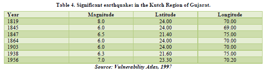
The earthquake affected area lies in seismic zone V, the highest risk zone, as per the seismic zone map of the country. This region had faced severe earthquakes in the past as well.
Some of the major earthquakes of this region are listed in Table 4.
Damage caused by the Bhuj earthquake
The earthquake caused substantial loss of life and property. The initial death toll was reported in the range of more than 20000. About 1,67,000 people received injuries of varying proportions.
As per the estimates, over five lakh houses were damaged and more than three lakhs destroyed. Heavy damages occurred to the infrastructure of health and education sector. About 12000 primary health centers in rural areas were damaged. About 9600 primary schools, 2040 secondary schools and 140 technical education and higher education buildings were damaged due to the earthquake. Heavy damages to rural water supply were reported. Similar type of damage and destruction was observed from the industrial sector as well, where buildings of small-scale, medium-scale and large-scale industries were damaged in big numbers. Infrastructure belonging to cottage industries and handicrafts were also affected. Facilities like roads, telecommunication, and electricity were paralyzed, many cities in Gujarat faced serious damage. Ahmadabad, the biggest city of the State, was devastated although it is about 300 km from Bhuj. Gujarat, being the second most industrialized state in the country, took a heavy beating in terms of adverse socio-economic impacts. The initial estimates put the total loss in Gujarat due to this earthquake at around Rs. 15000 crores.
In fact, the damage would have been much more but for the facts that Bhuj is a less populated area, the earthquake had a deep focus, and it occurred in day time when people were awake and mostly in the open on a holiday. Nevertheless, this was the worst earthquake in the country in recent decades in terms of the dead and injured and also property loss.
RESCUE AND RELIEF
The initial efforts were to restore the essential services like telecommunication, electricity, water supply and law and order in the affected areas. A large number of personnel from various departments were pressed into relief and rescue operations. In all about 36 units of Army Engineers, 34 companies of Paramilitary Forces, over 3000 Police personnel, 2600 Home Guards, 480 engineers, over 120 senior administrative staff and over 11000 other administrative staff were involved in these operations. Medical teams moved from all parts of the country. To coordinate such a huge relief operation, a number of control rooms were established/ reactivated at the State Headquarters and other places.
Response of national and international community was tremendous in providing by sending search and rescue teams and equipment besides relief material.
As Gujarat was having a very well-established industrial sector, number of private industrial houses aided in all possible manner to the State Government in post disaster management. Number of private companies adopted villages for reconstruction and rehabilitation Works as well Gujarat has a very strong NGO network as well. This network has very well-known networks like SEWA (Self Employed Women's Association), which has a presence in all parts of the State. There are other NGOs as well. The NGO networks helped the affected people in restoring confidence, and meeting their demands.
RECONSTRUCTION AND REHABILITATION
The strategy adopted by the Government of Gujarat for reconstruction and rehabilitation of the affected areas was based on the following considerations:
- Clear reconstruction strategy with regard to housing
- Revival of the economy and reconstruction of the livelihood options
- Reconstruction of public services
- Community participation and specific role of NGOs and private sector
- Institutional arrangements for carrying out the main objectives of the strategy adopted
To oversee the post-earthquake reconstruction and rehabilitation work, an apex body designated as the Gujarat State Disaster Management Authority (GSDMA) was constituted in February 2001 under the chairmanship of the Chief Minister with a Central Implementing Group under the Chief Secretary for coordinating activities of various line departments.
The major objective of GSDMA is to undertake social and economic rehabilitation and resettlement of the affected community. This includes the new housing, infrastructure, economic rehabilitation, social rehabilitation and other related programmes. GSDMA was also entrusted to prepare programmes for mitigating losses on account of disasters as strategy for long-term disaster preparedness.
The GSDMA is also required to undertake research study on causes for losses on account of natural disasters and suggest remedial measures to minimize the same.
TSUNAMI GENERATING EARTHQUAKE, 2004
Tsunami (a Japanese word), if translated literally, would mean a harbor wave. It is called so, perhaps because Tsunami is most noticeable in harbors and not on the high seas. Scientifically speaking, Tsunami is a wave-train (a series of waves) generated in a large body of water (sea or ocean) due to an impulsive (sudden) disturbance of the floor (sea bed) that vertically displaces the water column. This sudden vertical displacement can occur due to a massive earthquake or underwater landslide or volcanic eruption or collapse or even the impact of a cosmic body. In most cases, sea bed earthquakes have been the trigger of tsunami waves which have savagely attacked coastlines (not only nearby but thousands of miles across) causing colossal loss of lives and devastating property damage. One such event occurred on 26 December, 2004 in Indonesia due to a massive seabed earthquake of magnitude 8.5+. Later, the United States Geological Survey assigned it the magnitude 9.0-a catastrophic seabed upheaval by any standard. The tsunami generated by this exceptionally powerful earthquake devastated the east coast of India (and Kerala Coast also to some extent). As the impact of a tsunami is as coastal flood, we have already discussed this event from the point of view of floods in the Unit No. 4 on case studies of floods. However, as the flood generating, mechanism is an earthquake, it becomes necessary to present a case study of this recent but very exceptional disaster event from the point of view of earthquake which, as said above, was the genesis of the killer tsunami of 26 December, 2004, which wreaked so much havoc on our east coast.
As said above, the causative trigger was the 9.0 magnitude earthquake with epicenter off the west coast of northern Sumatra in Indonesia. To get an understandable perception of the sudden burst of energy released by this earthquake, it may be stated that it was equivalent to the detonation of 32000 mega tones i.e. 32 x 109 tons of TNT. In other words, the energy released was very approximately equal to sudden and simultaneous explosion of 150,000 Hiroshima type atomic bombs. Furthermore, this burst of energy took place at a shallow focal depth of only 10 km.
This earthquake created a rare seismic event called "ringing of the earth like a bell" by generating reverberations of the entire globe. This "ringing" of the earth was calculated to be of the order of one millimeter of vertical motion of the entire earth's surface. Earth's spin rate also seemed to have been affected (made faster forever) due to the imbalance created in the distribution of mass in the globe by the massive displacement of rocks inside the earth due to this earthquake. The Asian map has been permanently altered by the movement of many small islands as much as 20 meters. This earthquake moved the entire big island of Sumatra about 30 meters southwest. According to the scientists at the National Geophysical Research Institute (NGRI) in Hyderabad, this earthquake has brought Indonesian territory closer to India by about 10 cm. These all appear to be small figures but these have profound geological, geographical and geodetic significance the full appreciation of which will be studied by scientists all over the world for many years to come.
Now coming to the generation of tsunami by seabed earthquakes, the destructive tsunamis are caused by sea-bed "Subduction Zone" earthquakes i.e. earthquakes occurring in an under-sea subduction zone. A subduction zone is that region where two tectonic plates converge towards each other at speeds of a few centimeters per year. Of the two tectonic plates, one composed of heavier oceanic material subducts (slips below) the other lighter plate of continental material. During this process, the two tectonic plates rub against each other; the lower plate dragging and flexing the upper plate slightly downward. When flexing exceeds the frictional strength of the inter-plate contact, the upper plate rebounds to its original position, thus creating sudden sea-bed displacement resulting in massive displacement of enormous volume of sea water.
The potential energy of vertical displacement gets converted into kinetic energy of horizontal motion because the vertically displaced water mass, acting under the influence of gravity, attempts to regain equilibrium by spreading out. This horizontal disturbance in the sea propagates outward as a tsunami. This explains basically how a massive sea-bed earthquake creating a sudden vertical displacement (elevation or subsidence) generates a tsunami.
It may be noted that tsunami extends deep down into the seawaters. This means that the crest (top) of a tsunami is just the tip of a very vast volume of seawater in motion. Soon after (within several minutes) of its commencement, the initial tsunami splits into two waves. One travels towards the nearby coast and is called "Local Tsunami" while the other that travels out to deep ocean is called the Distant Tsunami. The speed of both the tsunami waves depends on the depth of the water traversed and varies as the square root of the depth. Therefore, deep ocean tsunami (distant tsunami) travels faster than the local tsunami. Over the deep oceans, tsunami can attain speeds of 500 to 1000 km ph and therefore, it can travel large transoceanic distances without much loss of energy because the momentum is so great. That is how the tsunami generated by the Indonesian seabed earthquake of 26 December 2004 hit not only the Indian coast but travelled further on to impact he Somalia coast at a distance of-4500km from the epicenter.
Tsunami Warning
Since it is not yet possible to forecast earthquakes, it is not yet feasible to forecast the genesis of a tsunami. Nevertheless, once a tsunami is generated, it becomes a matter of detecting, evaluating, and forecasting of the wave in the ocean waters. For this, underwater pressure sensors, acoustic i sensors and sea level monitors (in situ or satellite-based) have been tried. Quick processing and evaluation and quick communication have to be built in any tsunami forecasting and warming system. At present the following systems are in operation.
Pacific Tsunami Warning System (26 nations collaborated).
Five Regional Systems (2 in USA and one each in Japan, Russia and French Polynesia).
Local Systems in Japan and Chile.
After the tsunami Disaster of 26 December 2004, India is also working on the establishment of a tsunami warning system.
Lessons Learnt
The biggest lesson learnt from these case studies is that it is not the earthquake that kills people; rather it is the impact of the earthquake (ground shaking or tsunami) which results in building collapse or flood wave that kill or injure the people and destroying the infrastructure and houses in the process. The lingering after effects of an earthquake event create depression, disease, loss of vocation and other socio-economic ill effects both in short-term and long-tern.
Earthquakes cannot be forecast but scientists have delineated the areas according to vulnerability. It has been brought out that India does not have any a seismic region, which means that no part of India is free from the likelihood of occurrence of earthquake. Therefore, the people and authorities all over the country have to be vigilant and prepared to face earthquakes more so in regions with higher chances of occurrence of earthquakes.
First and foremost, the people have to be aware of earthquake risk in their area and they have to learn the basic Do's and Don'ts to be observed before, during and after an earthquake. The houses and buildings should be designed to be quake-resistant and the existing constructions, if not earthquake-resistant, should be retrofitted. In enforcing earthquake resistant building codes, microzonation will be very' helpful arid cost-saver.
The mitigation plans developed by the States of Maharashtra and Gujarat after the Latur and Bhuj earthquakes can serve as excellent guidelines for other vulnerable states.
CONCLUSION
An earthquake can hit any part of India without notice and cause untold damage to life and property. A sea-bed earthquake can generate tsunami which can create havoc in the coastal areas. The three case studies presented in this research paper deal with three recent but typical cases. The Latur earthquake occurred in a relatively less earthquake-prone area but created so much destruction and deaths primarily because the houses were very vulnerable, being made of stones put together with mud plaster. Construction of quake resistant houses and retro-fitting of the existing houses is the prime need.
The Bhuj earthquake occurred in a highly earthquake prone area. Here also the construction was of poor quality as seen from the fact that even the multistoried buildings in Ahmadabad (300 km from Bhuj) crumbled. This again points to the need of observance of proper building codes. The third case study explained how a sea-bed earthquake can generate tsunami which can devastate coasts thousands of kilometers away from the epicenter. Here the solution lies in detecting the tsunami as soon as it is generated and track it with the aim of warning the vulnerable coasts. There are Tsunami warning systems in operation in other parts of the world although they cannot as yet be said to be perfect. India is also now working on establishment of a Tsunami Warning System for its coasts.
- Bolt, B.A. (1988). Earthquakes WH Freeman and Company New York.
- Dowrick, D. (2003). Earthquake Risk Reduction. JohnWiley & Sons Ltd., Sussex, England.
- EERI, (1986). Reducing Earthquake Hazard Lessons Learned from earthquake Publication 86-02. EERI California.
- Gere, J.M. & Shah, H.C. (1984). Terra Non Firme Understanding and Preparing for Earthquakes W.H. Freeman and Co New York.
- Government of India BIS Code of Practice for Earthquake Resistant Design and Construction of Bui1dings 4326:1339.
- Government of India BIS (1993). Criteria for Earthquake Resistant Design of Structure.
- Government of India BIS (1993). A Manual of Earthquake Resistant Non-Engineered Construction.
- Government of India BIS (1993). Explanatory Handbook on Codes for Earthquake Engineering SP22(S&T).
- Government of India BIS (1993). Guidelines for Repair and Seismic Strengthening of Buildings.
- Government of India BIS (1993). Improving Earthquake Resistance of Earthen Buildings Guidelines IS 13827.
- Government of India BIS (1993). Improving Earthquake. Resistance of Low Strength Masonry Building Guidelines IS 13828.
- Killari Earthquake (1996). GSI Special Publication 37.
-
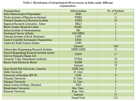
 Table 1
 -
Table 2
-
Table 3
-
Table 4


